Sunday, March 29, 2015
Chinese South China Sea Reclamation Projects Hamper Philippines, Others’ Claims
By Simone Orendain
 In this photo taken Feb. 28, 2013 by a surveillance plane, and released Thursday, May 15, 2014, by the Philippine Department of Foreign Affairs, Chinese-made structures stands on the Johnson South Reef (Đá Gạc Ma), called Mabini by the Philippines.
MANILA—China is forging ahead with reclamation projects on at least seven tiny but hotly contested features in the South China Sea, posing what could be a major challenge in the Philippines' international arbitration case against China.
 In this photo taken Feb. 28, 2013 by a surveillance plane, and released Thursday, May 15, 2014, by the Philippine Department of Foreign Affairs, Chinese-made structures stands on the Johnson South Reef (Đá Gạc Ma), called Mabini by the Philippines.
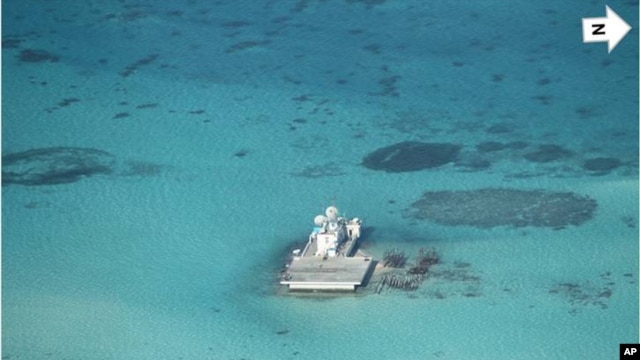
MANILA—China is forging ahead with reclamation projects on at least seven tiny but hotly contested features in the South China Sea, posing what could be a major challenge in the Philippines' international arbitration case against China.
Surveys of the disputed outcroppings will be key.
Since the beginning of the year, various satellite images of Chinese reclamation work in the Spratly Islands have shown shoals and reefs turning into artificial islands.
Since the beginning of the year, various satellite images of Chinese reclamation work in the Spratly Islands have shown shoals and reefs turning into artificial islands.
Major harbors that can dock military ships are nearly completed.
So are several airstrips and at least three multistory buildings where bare outposts once stood.
Philippine Foreign Affairs Secretary Albert del Rosario said at a forum in Manila Thursday his government has protested what he calls “the massive reclamation activities” of China.
“The alteration of these features [is] plainly intended to change the character, status and maritime entitlements of the said features, which prejudice the arbitration and undermine work of the arbitral tribunal to hear and objectively decide the case,” said del Rosario.
In January 2013, the Philippines filed a case with the International Tribunal for the Law of the Sea seeking affirmation on features it is contesting with China based on definitions of international law. Just about every single feature included in the filing now has Chinese reclamation work in progress. The case also questions what Manila calls Beijing’s “excessive claims” in the South China Sea. China opted out of arbitration in certain cases when it signed on to the U.N. Convention on the Law of the Sea and it rejects the filing.
China has said it has “indisputable sovereignty” over practically the entire sea.
Brunei, Malaysia and Vietnam also have claims in the resource-rich sea.
The Philippine argues that certain features China took over are “low tide elevations,” meaning at high tide they are completely submerged.
The Philippine argues that certain features China took over are “low tide elevations,” meaning at high tide they are completely submerged.
It says these are far from China’s territorial sea, which makes them either part of another state’s continental shelf or part of the international seabed.
The Philippines also deems four reefs “rocks,” saying even if they are above sea level at high tide, they are uninhabitable “and incapable of supporting economic life in their natural state.”
When features are disputed, international law does not recognize their altered states.
When features are disputed, international law does not recognize their altered states.
But there has to be proof of what they were before they were changed.
Gregory Poling, who specializes in the disputes in the South China Sea at the Washington-based Center for Strategic and International Studies, said such cases are rare and in the only other case he could recall, the international court’s standards were tough.
“They needed on the ground surveys, at not just high tide, but the highest tide of the year. It was a much higher bar than say, a few flyovers for satellite imagery,” said Poling.
University of the Philippines Institute for Maritime and Ocean Affairs director Jay Batongbacalsaid that until 2010, the Philippines had solid surveys of the features it claims in the Spratlys.
“However, if for example the tribunal were to say, well, they don’t think that the evidence presented is good enough and they would ask for newer, better surveys, then clearly it would be impossible,” said Batongbacal.
Also, Batongbacal said, the features that could be surveyed are too close to Chinese and Vietnamese positions.
He and Poling say timing of the surveys is important because they need to have been done before reclamation work started.
Henry Bensurto, a San Francisco-stationed consul general who heads the Philippine Foreign Affairs Department’s legal team on the arbitration case, said the Philippines is strengthening its case through a “holistic approach.”
He said the Philippines has submitted flight surveillance imagery of the islands, low-tide elevations, and rocks as well as their anthropological and historic background.
“Because this is important to have a better appreciation of the features not in just one instance of history but over a period of time. Because that’s very important also, especially if you’re going to define [an] island as capable of sustaining human habitation,” said Bensurto.
The Permanent Court of Arbitration in The Hague has yet to determine whether it has jurisdiction over the case.
Beijing says it does not because Manila’s filing is essentially about maritime borders and delimitations, which the court cannot rule on.
Manila is confident the Court has jurisdiction and it expects a ruling on both jurisdiction and the merits of its claim by early next year.
Poling thinks the Court will likely make a determination only on the sweeping claim argument and leave the question of the features alone because “it gets too close to the delimitation issue.”
No comments:
Post a Comment
Comments always welcome!